Showing 110 items matching township and bridges
-
 Clunes Museum
Photograph
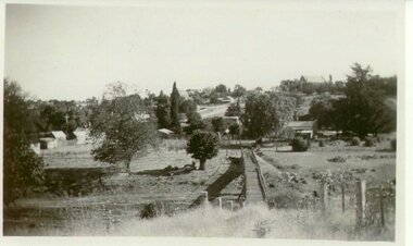
VIEW OF SUSPENSION BRIDGE WITH TOWNSHIP IN THE DISTANCEsuspension bridge, local history -
 Clunes Museum
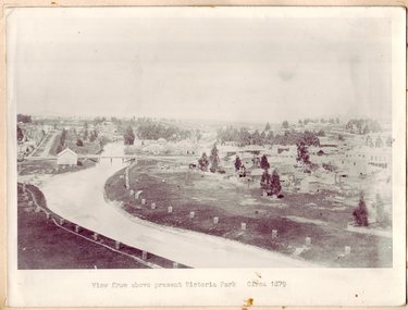
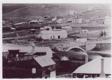
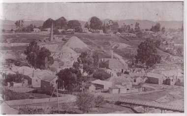
Photograph, CIRCA 1879
PHOTOGRAPH OF CLUNES TOWNSHIP, SHOWING THE TWO BRIDGES ACROSS THE CREEK.VIEW FROM ABOVE PRESENT VICTORIA PARK.local history, photography, photographs, bridges - buildings and landscape of clunes -
 Clunes Museum
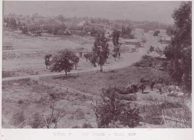
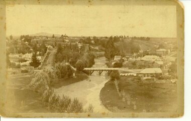
Photograph
PART OF CLUNES TOWNSHIP FROM CAMP PARADE.TOWNSHIP VIEW OF CLUNES, FROM LOWER FRASER STREET, TWO BRIDGES IN PICTURE.CLUNES FROM CAMP PARADE. CIRCA 1897local history, photography, photographs, clunes township -
 Glenelg Shire Council Cultural Collection
Postcard - Postcard - Suspension bridge Casterton, 1900-1930
SOURCED FROM CASTERTON TOWN HALL (FORMER SHIRE OF GLENELG) Sourced from Casterton Town Hall (Former Shire of Glenelg)Postcard, black and white,, showing the suspension bridge at Casterton, view across river towards townshipFront: 'SUSPN BRIDGE CASTERTON' Back: Handwritten correspondence, addressed to 'Miss M. Sythaleigh, Henty St Casterton' -
 Hume City Civic Collection
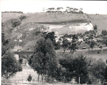
Photograph, Early 1970s
... bridges ...The Kaolin Quarry at Bulla supplied Kaolin to the Northcote and Brunswick Pottery Works until it ceased operation at that site in the 1950s. The three arched bluestone bridge r3placed a ford crossing across Deep Creek, which along with Jacksons Creek flows into the Maribyrnong River.A black and white photograph of the Deep Creek and three arched bluestone bridge in the Bulla Township with the Kaolin Quarry in the background. One truck is crossing the bridge with a tanker approaching the bridge at the bottom of the Bulla Hill.deep creek, bridges, kaolin quarries, quarries, george evans collection -
Clunes Museum
Photograph
Black and white framed photograph of the township of Clunes looking over bridge to Service Street and Fraser Street cornerservice street, fraser street, clunes streets -
 Clunes Museum
Photograph
BLACK & WHITE PHOTOGRAPH GENERAL VIEW CLUNES TOWNSHIP WITH GOVERNMENT BRIDGE IN CENTRE OF PHOTOGRAPH, EBERHARD SOFT DRINK FACTORYphotographs, township, goverment bridge -
Glenelg Shire Council Cultural Collection
Negative - Negative - Glenelg River, Victoria, c. 1934
Part of a collection of photographs taken by Zillah Maschmedt in 1934. Zillah was a teacher from South Australia.Transparency for black and white photo. View along Glenelg river at Nelson, Victoria. Township on right, bridge centre of the photo.zillah maschmedt, photography, glenelg river -
Glenelg Shire Council Cultural Collection
Negative - Negative -Glenelg River Nelson, Victoria, Miss Zillah Maschmedt, photographer, c. 1936
Negative for a black and white photograph. Image shows view across Glenelg River to Nelson township, bridge in foreground Nelson Victoria. -
 Hume City Civic Collection
Photograph, Early 1970s
In the early 1970s the eastern approach to Sunbury was changed. The stone bridge spanning the Jacksons Creek was replaced by a wider concrete structure and dangerous curves were taken out of the road. The area on the LHS of the photograph including the two arched stone bridge has been incorporated into a public picnic area.A black and white panoramic view of the eastern approach to Sunbury and the Sunbury township before the road was widened and straightened and the new bridge was built. There are two cars in the foreground. One is approaching the bridge and the other is leaving Sunbury.macedon street, macedon street road bridge, jacksons creek, sunbury township, george evans collection -
 Clunes Museum
Photograph, J. BAWDEN PHOTOGRAPHER STUDIO FRASER STREET, CLUNES, CIRCA 1890
TULLAROOP CREEK FROM "ROCKS" NEAR SITE OF PORT PHILLIP MINE. ABOUT 1890 - NOTE GOVERNMENT BRIDGE IN DISTANCE. THIS WAS REBUILT IN STRAIGHT STEEL GIRDERS IN 1896.ORIGINAL SEPIA PHOTOGRAPH OF TULLAROOP CREEK, IN FOREGROUND VIEWS OF CLUNES TOWNSHIP. TWO MILE HILL IN LEFT FAR DISTANCE. (SUSPENSION BRIDGE IN FOREGROUND)local history, photography, photographs, bridges - buildings and landscape of clunes -
Glenelg Shire Council Cultural Collection
Postcard - Postcard - Nelson, Victoria, n.d
Coloured photo postcard, aerial view of Nelson, Victoria, showing the bridge, township and river mouth. Rose Series De Luxe colorview NO 1213Back: Maker details. 'Aerial view of Nelson Victoria'postcard, nelson -
 Phillip Island and District Historical Society Inc.
Photograph, 1969
One of 16 photographs and postcards donated by Mary KarneyBlack & White Aerial photograph of the two bridges linking San Remo with Newhaven, Phillip Island. San Remo Jetty and township bottom left foreground. Newhaven on the top.On back: "Two bridges San Remo 1969."the two bridges san remo, san remo to newhaven, phillip island bridges, mary karney -
Clunes Museum
Memorabilia - CALENDAR, R. FLETCHER & SONS. BALLARAT, 2013
1 x paper sheet of Clunes Fire Brigade printed in colour showing images of Clunes Town Hall, Clunes Township and the Government Bridge, (courtesy of Jenny Anderson)Nil2013, clunes fire brigade -
Glenelg Shire Council Cultural Collection
Painting, George H.L Pentland, Casterton 1889, 1889
Casterton & District Historical Society Inc.Painting, oil on canvas showing a 'bird's-eye' view' of the township of Casterton in the late 19th century. It shows the Glenelg River, the bridge, main street and rolling landscape of the Western District.casterton, oil painting, landscape -
 Orbost & District Historical Society
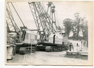
black and white photographs, 1974 - 1976
Construction of the roadway embankment between the bridges across the Snowy River flood plains at Orbost commenced in January 1974 and was completed in November 1976. Pearsons were the bridge contractors for the construction of the Princes Freeway and bridges across the river flood plains at Orbost. Heavy rains and floods held up progress.These photographs are of the construction of a major structure in Orbost. The opening of this Snowy River Bridge was an important development in the accessibility to the township of Orbost.Four black / white photographs of construction sites. 3241.1 is of three cranes and other machinery with six persons. 3241.2 is of workmen working on flooded site. 3241.3 is a photograph of the early stages of construction of a bridge looking towards the township. 3241.4 shows the construction of a roadway between the bridges.construction-snowy-river-bridge bridge-orbost -
 Clunes Museum
Photograph
BLACK AND WHITE PHOTOGRAPH OF CLUNES TOWNSHIP. SMOKE STACKS, MULLOCK HEAPS, TWO POPPET HEADS, TWO BRIDGES OVER CREEK, DWELLINGS. SEVERAL LARGE TREES AND SMALLER TREES IN TREE GUARDS.local history, photography, photographs, clunes township -
 Phillip Island and District Historical Society Inc.
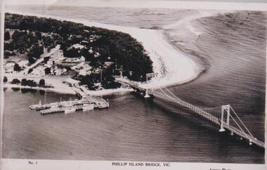
Photograph, Phillip Island Bridge, 1940
... bridges ...The bridge built around 1939. Fishing fleet. Twin jetties to left of bridge, township, bush and wide sand strip of surf beach.Bridge between Phillip Island and San Remo. Photograph depicting San Remo onlyNo. 1. Phillip Island Bridge, Vic. Airspy Photolocal history, photographs, bridges, san remo, coastline, bridge, fishing fleet, jetties, bruce bennett -
 Phillip Island and District Historical Society Inc.
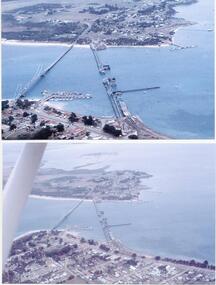
Photographs/Slides, Laurie Dixon, 1960's
Four of a collection of slides taken by Laurie Dixon. (Scanned by E Alexander) The new bridge was built in 1968.Four coloured photographs scanned from slides. Three aerial views. 273-01. Aerial view of the old and new bridges and Newhaven, San Remo and Churchill Island - extra close up of same photo. 273-02. Aerial view of the old and new bridges looking towards Cape Woolamai on the top right. 273-03. Aerial view of the Cowes Pier and township - extra close up of same photo. 273-04. Looking down the Cowes Pier towards the township with Isle of Wight Hotel in the background.273-03. Inscription on the slide: Cowes from the air Jan 1968.phillip island suspension bridge, two bridges phillip island, san remo, newhaven, laurie dixon, cowes pier, cowes pier phillip island -
 Hume City Civic Collection
Photograph, 1960s
... bridges ...The two-arched bluestone bridge which spans the Jacksons Creek at the east end of Sunbury township, was built in 1857 and continued to be used as a road bridge on the main Sunbury Road-Macedon Street until the early 1970s when a wider bridge replaced the original bluestone bridge.A black and white photograph of a two- arched bluestone bridge which spans a dry creek bed. A bulldozer is on the riverbank on the RHS of the photograph.bridges, bluestone bridges, jacksons creek, harris, thomas lascelles, macedon street, george evans collection -
 Buninyong & District Historical Society
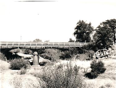
Photograph - Photo of Original Photograph, W. Jack, Buninyong Railway Station precinct in 1940, 9 June 1940
Railway station and surrounds in 1940.B/W photograph f Buninyong Railway station precinct, taken 9 June 1940, showing Barkly St. trestle bridge over railway cutting, Butter Factory on left, station and rail yards on left, township to thye right.buninyong, railway, bunny, butter factory, bridge, cutting, barkly st. -
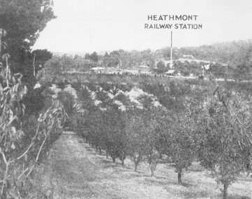 Ringwood and District Historical Society
Photograph, View of what was Heathmont township taken from about Royal Avenue looking at Mr. Herman Pump's orchard. Old bridge over Canterbury Road can be seen on left
Typed below photograph, "View of what was Heathmont township taken from about Royal Avenue looking at Mr. Herman Pump's orchard. Old bridge over Canterbury Road can be seen on left." -
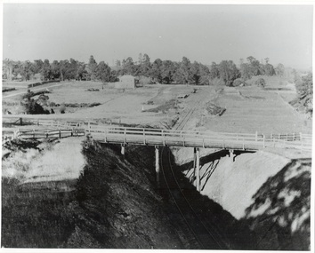
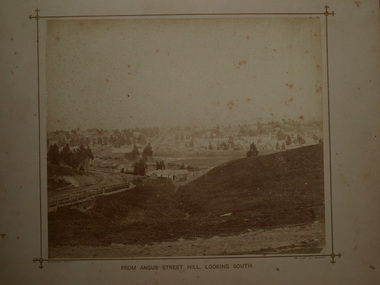 Clunes Museum
Photograph, BEAUCHAMP PHOTO 104 STURT STREET, BALLARAT, FROM ANGUS STREET HILL, LOOKING SOUTH, 1879
PHOTOGRAPH OF TOWNSHIP OF CLUNES ABOUT 1875. LOOKING SOUTH. WOODEN BRIDGE IN FOREGROUND, 1 SEPIA PHOTOGRAPH MOUNTED ON CARDBOARD .2 SEPIA PHOTOGRAPH MOUNTED EDGES REMOVED .3 BLACK AND WHITE PHOTO PRINT .4 BLACK AND WHITE PHOTO PRINT .5 PHOTOCOPY OF PHOTOGRAPHFROM ANGUS STREET HILL LOOKING SOUTHphotographs, clunes township and mining and footy oval -
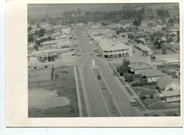 Orbost & District Historical Society
black and white photographs, C 1960s - 1970s
3290.1 is an aerial photograph of the township of Orbost looking south along Nicholson Street. The tennis courts and recreation reserve are on the left. The War Memorial, Commonwealth Hotel at the Saisbury Street intersection is in the centre of the photograph. 3290.2 is an aerial view of the Orbost township looking north, showing the bridge across the Snowy River in the foreground,These photographs are detailed pictorial records of the Orbost township C 1960s - 1970s.Two photographs which are aerial views of a township showing streets, buildings and vehicles. 3290.1 is a black / white photograph. 3290.2 is a coloured photograph.orbost-township-c1960s-1970s aerial-photograph-orbost -
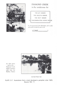 Eltham District Historical Society Inc
Work on paper (Sub-Item) - Photograph, Illustrations from a land developer's pamphlet promoting Diamond Creek, circa 1925
Photos illustrating the Diamond Creek with a bridge over it and two people sitting by the creek, one is fishing with text describing the kind of person who may like to come to the township. diamond creek, advertising, promotion, land development, real estate -
 Phillip Island and District Historical Society Inc.
Photograph Folder, approx 1940's - 1950's
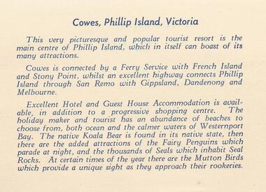
Coloured Souvenir folder of 12 postcards donated by M Arnell.Souvenir Colour Folder of 12 colour postcards of Cowes and Phillip Island. Photographs Include: Cowes Beach, Cowes Pier, Koalas, Cowes Township, The Nobbies, Summerland Surf Beach, Suspension Bridge, Thompson Avenue, Cowes, Penguin Parade, Seal Rocks, The Isle of Wight Hotel and The Blowhole.Front cover: A Souvenir of Picturesque Cowes. A Special selection of Scene in Full Colour.phillip island, cowes phillip isand, the isle of wight hotel cowes phillip island, the blowhole phillip island, penguins, koalas, seals, m arnell -
 Orbost & District Historical Society
black and white photographs, February 17 1971
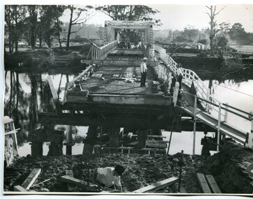
After the damage from the February 1971 floods at Orbost when the abutment to the Snowy River road bridge was washed away a Bailey bridge, portable, pre-fabricated, truss bridge, was put into place to ensure town access, the C.R.B. rebuilt the approach to the bridge driving new piles and constructing the Bailey bridge. They worked late into the night under flood lights to ensure the link from the Orbost township to the Princes Freeway would be open to traffic as soon as possible.These photographs are pictorial records of a significant event in the history of Orbost.Three black / white photographs of a Bailey bridge being erected across a river. 3245.1 and 3245.2 are the same. bailey-bridge orbost-snowy-river-bridge bridge-orbost -
 Orbost & District Historical Society
black and white photographs, 25.11.1976
These photographs were taken on November 25, 1976 at the official opening of the current Snowy River road bridge. Included in the photographs are: John Duggan; Pat Hall, C.R.B. chairman, R.E.V. Donaldson (3240.7) and J.A.Rafferty, the state minister for Transport, who cut the ribbon (3240.8). Di Young and Cheryl Dusting (3240.9) distributed souvenir information pamphlets to official guests. The Snowy River road bridge is one of four built as part of the 8.4 km project spanning the Orbost flood plains. The Snowy River bridge and another over the nearby Ashbys Gulch are among the 10 longest bridges in Victoria, being the eighth and fifth longest respectively. The new bridge removed through traffic from Orbost township crossing the Snowy River 45 m downstream of the old bridge.This bridge is the fourth to provide a crossing to the township of Orbost. (info from CRB NEWS No. 34. DECEMBER, 1976) These photographs are pictorial records of a significant event in Orbost's history.Eleven black / white photographs all related to the official opening of the current Snowy River Bridge. Details are in catalogue folder.snowy-river-bridge -
 Sunbury & District Heritage Association Inc
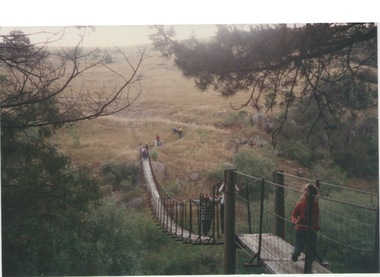
Photograph, Catanery Bridge, Bulla, c1980s
... bridges ...The narrow swing catanery bridge was built behind the school across the Deep Creek downstream from the bluestone Bulla Bridge. It was built so that children who lived on the south side of Bulla Township could access the school more easily and in shorter time than if they had to go by the main roads.The bridge was constructed in the days when most children walked to school. The use of this bridge cut the children's travel time and distance to school quite considerably and was used for many years until the school was closed in 1996.A coloured photograph of the children on a narrow swing bridge and the path they used to approach the bridge over open ground. bulla primary school, swing bridge, bridges, catanery bridge -
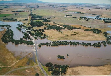 Lake Bolac & District Historical Society
Colour photograph, Wickliffe Flood, Jan .2011
Wickliffe, the flooded Hopkins River flowing from left to right, both under and over the bridge, showing the inundated Glenelg Highway and township. January, 2011. Photograph courtesy James Davidson.wickliffe, hopkins river, flood, glenelg highway